http://e-info.org.tw/node/116947
同一塊地養魚又種菜 孟加拉新農法專抗海水倒灌
文字大小
837 2 Share1
本報2016年7月8日綜合外電報導,姜唯編譯;蔡麗伶審校
孟加拉是全球氣候變遷風險最高的國家,面對海水不斷入侵低窪陸地,為了保障糧食生產,當地非政府組織教導農民把土壤堆成一排排約90公分高、1公尺寬的土堆,在上面種植各種蔬菜,土堆之間的溝則積水養魚。這種名為「Sarjan」的新農法已相當盛行,也成功提升了氣候變遷之下的作物產量。
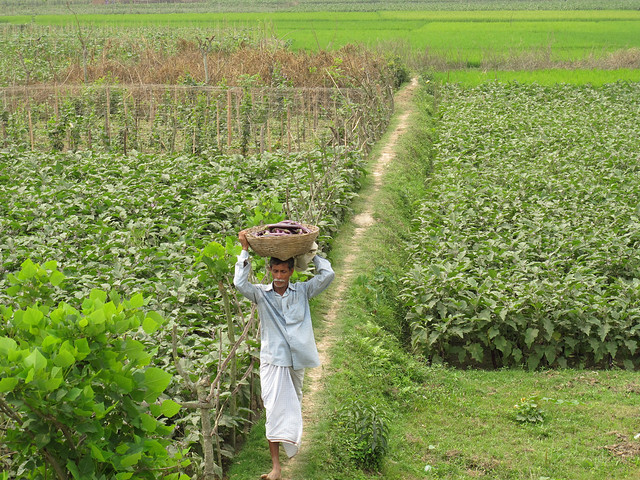
孟加拉一名農民收成了茄子。攝影:Todd Post。圖片來源:Bread for the World(CC BY-NC-ND 2.0)。
七成土壤瀕臨鹽化 孟加拉糧安受威脅
孟加拉灣南部的潮汐河口和泛濫平原地勢低漥、人口稠密。這裡的耕地佔全國的30%。一份近期研究發現,因為上游淡水減少,海水入侵、地下水鹽化和土壤鹽分波動等現象可能嚴重影響孟加拉的糧食生產。
IPS報導,根據鹽度調查、鹽度監控資訊和《土地土壤資源利用指南》的解釋,孟加拉南部沿海地區約100萬公頃,等於是70%的灌溉土地有不同程度的鹽化問題。已經有預測指出,如果目前氣候變遷的趨勢持續下去,稻米產量可能減少10%,小麥產量可能減少30%。
孟加拉農業研究所(Bangladesh Agriculture Research Institute, BARI)首席科學家Mohiuddin Chowdhury博士指出,沿海地區土壤鹽度和溫度有直接關係。溫度上升使土壤失去水分,潮汐或暴風雨使鹽分濃度變高,導致作物枯萎或死亡,這些現象已經相當常見。
孟加拉深受海水上升之苦數十年,土壤鹽化影響了全年的作物產量。沿岸來自上游的新沖積土壤不但接觸到海水,更持續浸泡在漲潮以及透過溪流湧入的海水中而變鹹。根據土壤資源發展研究所(Soil Resource Development Institute)2010年的資料,受海水污染的土地面積從1973年的8330平方公里增加到2009年的1萬560平方公里。
根據2014年的氣候變遷脆弱指數(Climate Change Vulnerability Index)報告,孟加拉是全球氣候變遷風險最高的國家。孟加拉沿海地區海平面上升相當明顯。97%的沿海地區、超過4000萬居民處在多重氣候危機之中。
儘管努力加強適應能力,氣候變遷仍持續造成龐大經濟損失、經濟成長遲緩,且拖累減貧進度。Chowdhury重視適應措施和作物管理,因為此刻氣候變遷已經「無可避免,只能與之共存。」
沿海地區發展Sarjan新農法 有效提升產量
為了因應氣候挑戰,依靠傳統農法維生的沿海農業社群改採能讓收成更豐更穩定的科學農法。BARI耗時多年研究,最終成功發展出最適合沿海地區的農法,其中一種叫做「Sarjan」,是現在相當普遍的農法。
孟加拉最活躍的非政府組織之一「社會轉型信託海岸協會」(COAST)在協助農民適應沿岸變化中扮演關鍵角色。COAST在Char Fasson地區執行的「沿海綜合技術推廣計劃」(CITEP)自2003年起協助農民改採替代農法,以改善氣候變遷之下的作物產量。
CITEP鼓勵農民採行Sarjan農法,將土壤堆成一排排約90公分高、1公尺寬的土堆,在上面種各種蔬菜,土堆之間的溝積水養魚。灌溉土地的水引自附近梅克納河水匯積的淡水湖。
這樣的農法可以在暴風雨、漲潮、洪水時保護作物不被淹沒,也避免鹽分過高,現在在Char Fasson相當流行,超過9000位農民採用。許多農民更組成自助會,與他人分享經驗。
CITEP用示範田指導數百位農民新的農法。「我們開發了許多不同的農法,可以在不同鹽度下栽種作物,都已經證實有用。」BARI總幹事Mondol博士說。

Aid, Asia-Pacific, Climate Change, Development & Aid, Economy & Trade, Editors' Choice, Environment, Featured,Food & Agriculture, Green Economy, Headlines, Natural Resources, Poverty & SDGs, TerraViva United Nations,Water & Sanitation
Aquaculture Meets Agriculture on Bangladesh’s Low-Lying Coast
 Print
Print
Bangladeshi farmer Aktar Hossain using the Sarjan model. He just planted eggplant (known locally as brinjal) worth 700 dollars and released fish worth 240 dollars. Hossain expects a profit of 1,200 dollars by the end of the season. Credit: Naimul Haq/IPS
- A continuous influx of sea water is threatening agriculture and food security in vast coastal areas of Bangladesh, but farmers are finding ways to adapt, like cultivating fish and crops at the same time.
The coastal and offshore areas of this low-lying, densely populated country include tidal estuaries and river floodplains in the south along the Bay of Bengal. Here the arable land is about 30 percent of the total available in the country.
In a recent study, experts observed that salinity intrusion due to reduction of freshwater flow from upstream, salinization of groundwater and fluctuation of soil salinity are major concerns and could seriously hamper country’s food production.
According to salinity survey findings, salinity monitoring information, and interpretation of Land and Soil Resource Utilization Guides, about one million hectares, or about 70 percent of cultivated lands of the southern coastal areas of Bangladesh, are affected by various degrees of soil salinity.
It is already predicted that if the current trend of climate change continues, rice production could fall by 10 percent and wheat by 30 percent.
Dr. Mohiuddin Chowdhury, principal scientific officer of Bangladesh Agriculture Research Institute or BARI, told IPS, “We are indeed greatly concerned by the loss of arable land in the coastal areas that is already happening and the future from the past trends looks bleak.”
Dr. Chowdhury explained that salinity in the coastal regions has a direct relation with temperature. If the temperature rises, the soil loses moisture and the salt from tidal or storm surges becomes concentrated, which results in crops wilting or dying – a phenomenon that is is already widely evident.
Dr. Chowdhury stressed adaptation measures and crop management, since at this point, climate change “cannot be avoided, but we have to live with it.”
Salinity in Bangladesh, one of the countries worst affected by decades of sea level rise, causes an unfavorable environment that restricts normal crop production throughout the year. The freshly deposited alluviums from upstream in the coastal areas of Bangladesh become saline as it comes in contact with the sea water and continues to be inundated during high tides and ingress of sea water through creeks.
A study found that the affected area increased from 8,330 square km in 1973 to 10,560 square km in 2009,according to the Soil Resource Development Institute in 2010.
Despite efforts to increase resilience, climate challenges continue to result in large economic losses, retarding economic growth and slowing progress in reducing poverty.
To confront the challenges, farming communities in the coastal areas that always relied on traditional agricultural practices are now shifting to research-based farming technology that promises better and safer food production.
The chief of BARI, Dr. Mohammad Rafiqul Islam Mondal, who describes climate change as a tragedy, told IPS, “At BARI, we are concentrating on developing agriculture practices towards adaptation to the extreme weathers, particularly in the coastal regions.”
Recognizing the adaptation strategies, BARI, blessed with years of research, has successfully introduced best farming practices in coastal regions. One is called the Sarjan model and is now very popular.
A leading NGO in Bangladesh, the Coastal Association for Social Transformation Trust (COAST), which has over 35 years of experience working mostly in coastal areas, has played a key role in supporting farmers with adaptive measures.
During a recent visit to an island district of Bhola, this correspondent witnessed how COAST in collaboration with the local agriculture department has introduced the farming model that is making huge positive impacts.
Mohammad Jahirul Islam, a senior COAST official in Char Fasson, a remote coastal region barely 30 cms above sea level, told IPS, “The traditional agricultural practices are threatened, largely due to salt water intrusion. High salt concentration is toxic to plants and we are now forced to seek alternative ways of growing crops.”
The Coastal Integrated Technology Extension Programme (CITEP) being implemented by COAST in Char Fasson has been helping farmers since 2003 with alternative farming practices to improve crop production in the face of climate change.
As part of its capacity-building programmes, CITEP encourages farmers to use the Sarjan model of long raised rows of soil about one metre wide and 90 cm high for cultivating varieties of vegetables. The trenches between the rows are filled with water into which various types of fish are released for maturing. The water for irrigating the plants comes from nearby lakes filled with freshwater drawn from the Meghna River.
The advantage of using Sarjan model is that it protects cropland from inundation during storm surges, tidal waves and flash flooding and avoids high salinity.
CITEP project coordinator in Char Fasson, Mizanur Rahman, told IPS, “These lowlands, hardly 25 kms from the sea at the confluence of the Bay of Bengal, are prone to tidal waves and storm surges during the seasons. So the recent farming models introduced here have been designed to protect the crops.”
According to Sadek Hossain, a veteran farmer who is already benefitting from the Sarjan model, said it “is safer and gives risk-free crops as the spaces between the crops allow more sunlight exposure and also has far less pest attacks.”
The new farming practice has turned out to be very popular in Char Fasson, where over 9,000 farmers are now using the model. Many farmers have also formed self-help groups where members benefit from sharing each others’ experiences.
Manzurul Islam, a local official of the government’s agriculture department in Char Fasson, told IPS, “At the beginning, the challenges were huge because farmers refused to adapt to the new model. Realising the benefits farmers are now convinced.”
Losses of crops on flat lands are disastrous. Mohammad Joynal recalls how tidal waves three years ago destroyed huge crops. “We were helpless when the crops were inundated on about 5,500 hectares of flat land. The sea water inundation for four months caused all crops to wilt and eventually rot,” said a dishearten face of Joynal.
Hundreds of farmers have been trained using demonstration crop fields on the adaptation techniques. “We have many different models developed to grow crops at different levels of salinity which are already proven successes,” said BARI Director General Dr. Mondol.
Sea level rise is already evident in coastal Bangladesh. Projections show that 97 percent of coastal areas and over 40 million people living in coastal Bangladesh are vulnerable to multiple climate change hazards.
The Climate Change Vulnerability Index (CCVI) for 2014, which evaluated the sensitivity of populations, the physical exposure of countries, and governmental capacity to adapt to climate change over the following 30 years, ranks Bangladesh as the number one economy in the world at risk to climate change.
Globally, emissions of carbon dioxide and chlorofluorocarbons into the atmosphere are growing at a rate of 5 percent annually, according to a joint publication by COAST and the Equity and Justice Working Group (EJWG) on ‘Climate Change Impact and Disaster Vulnerabilities in the Coastal Areas of Bangladesh’.
Rezaul Karim Chowdhury, executive director of COAST Trust and one of the authors of the joint publication, told IPS, “The impacts of climate change with time would become more acute hitting right at the core of our economy – agriculture on which over 70 percent of our rural population rely on.”
Rezaul, well known for his contributions to development in the coastal regions, added, “We acted early considering the harsh realities of extreme weathers. Introducing the Sarjan model is one of many which we have successfully implemented, building capacities of the local farmers.”
沒有留言:
張貼留言